Facebook

Hiking Trails in the Great Smoky Mountains

Did you know there are more than 850 miles of hiking trails in the Great Smoky Mountains? This makes the Bearskin Lodge a perfect starting point for a great adventure. The trails range from easy to difficult and provide opportunities for everything from half-hour walks to week-long backpacking trips. One of the most popular hiking trails is the Appalachian Trail, which runs through the Great Smoky Mountains for 70 miles along the park’s top ridge. Pets are not allowed on any trails except for the Gatlinburg Trail and the Oconaluftee River Trail, and backcountry camping requires a permit. With so many options for trails, the Smokies offer a tremendous number of hiking opportunities. Mentioned below are a few of the most popular and/or exciting destinations. All trails are described in round-trip miles.

view from clingman's dome
trees in park

Park Map

View Map
hiking trail signs

Trail Map

View Map
map icon

Map of Region

View Map
log cabin

Campground Maps

View Map
thumb_up

Popular Hikes in the Smokies

TrailLengthDifficultyDescription
Alum Cave4.4 milesModerateIt includes Arch Rock, a natural arch, Inspiration Point and the Alum Cave Bluff. Inspiration Point offers a spectacular view of the West Prong of the Little Pigeon River’s upper basin. The bluff resulted from Confederate mining of saltpeter during the Civil War. This trail continues to Mt. LeConte and its beautiful viewpoints. The round-trip distance from the parking area to LeConte is 10 miles.
Andrews Bald4.4 milesModerateThis hike heads downslope to a bald. Excellent views open to the south, toward Fontana Lake, and in the spring the azalea explode with color. This trailhead is not accessible by car from Dec. 1 to April 1.
Charlies Bunion8.0 milesModerateFollowing the Appalachian Trail, this hike goes out to rocky crags along the state line ridge. It has excellent views.
Chimney Tops4.0 milesStrenuousIt is a steep climb to two rock spires 4,755 ft in elevation. From the top, they provide a spectacular 360-degree view.
water

Hikes to Waterfalls

Name of FallsLengthDifficultyDescription
Abrams5.0 milesModerateThe trail begins in the back of Cades Cove Loop Road. Abrams Falls has the largest water volume of any park fall, and is among the most photogenic.
Chasteen Creek4.0 milesModerateThis is a hike out of the Smokemont Campground. A small but graceful fall, this area makes a good hike.
Grotto2.4 milesModerateOff the Roaring Fork Motor Nature Trail. It is through a hemlock dominated forest. Grotto Falls is distinctive as the only waterfall in the park one can walk behind.
Henwallow4.4 milesModerateTrailhead is near Cosby Campground, south of Cosby, TN. This 45-foot fall receives less visitation than many other area falls.
Juney Whank0.6 milesModerateThe trail starts near the end of Deep Creek Road near Deep Creek Campground.
Indian Creek1.5 milesModerateHike out of the Deep Creek Area. Sliding down 35 feet of sloping rock strata, the water livens and cools the air. Along the route is Toms Branch Falls, another beautiful fall.
Laurel2.5 milesEasyThe easiest waterfall hike on the Tennessee side of the park, the hike to Laurel Falls follows a paved trail. The trail cuts through the middle of a series of cascades. Laurel Falls is 60 feet high.
Rainbow5.5 milesModerate to StrenuousRainbow Falls, at 80 feet, is the highest single plunge waterfall in the park. This trail makes a good challenge and reveals a beautiful fall.
Ramsay Cascades8.0 milesStrenuousThe trailhead begins in the Greenbrier Area. Ramsay Cascades tumbles over 100 feet among a spectacular setting, creating a magnificent scene.
map

Hikes In & Around Cades Cove

TrailLengthDifficultyDescription
Anthony CreekVariesModerateThis is Cades Cove’s easternmost trail. It begins in the Cades Cove picnic area. Vehicles must leave the area 1 hour before sunset. To stay overnight, park by the ranger station. The trail follows Anthony Creek to its headwaters. After 3 miles, the trail reaches backcountry campsite #9. Camping in the backcountry requires reservations. After another mile, the path merges with Bote Mountain Trail. Destinations include Spence Field, the Appalachian Trail and Rocky Top. Rocky Top holds one of the park’s best vistas.
Cades Cove Nature2.0 milesEasyThis is a great trail for families. It is less than 1 mile past the Cades Cove Visitor Center and begins along the loop road. The 2-mile loop hike takes about an hour. A brochure explains more about the cove’s cultural and natural history. Despite its convenience, few people use this easy trail.
Cooper RoadVariedEasyThis little-used trail begins 4 miles from the loop entrance. It was once used for easy access to Cades Cove. It is a level, easy path. The trail ends at the park boundary, but many hikers turn around earlier.
Gregory Ridge8.0 milesStrenuousThe trailhead is on Forge Creek Road. Follow Forge Creek Road 2 miles. It ends as a parking lot. The 6-mile trail to Gregory Bald begins here. This tough trip gains 3,000 feet in elevation. Highlights of this trail include old growth forest with 8-foot diameter tulip poplars and the 10-acre bald.
Rich Mountain8.0 mile loopStrenuousThis trail begins on the right, before the entrance to the one-way loop road. Rich Mountain Trail offers quiet and isolation. The trail features beautiful views of Cades Cove and many wildlife viewing opportunities.
history_edu

Hikes to History

TrailDescription
Kephart ProngThe trailhead is located at the footbridge over the Oconaluftee River, 7.0 miles north of the Oconaluftee Visitor Center on Newfound Gap Road. The first 0.25 mile of trail passes by the site of an old CCC camp and fish hatchery.
Little GreenbrierPark at Metcalf Bottoms and walk across the bridge. Take the Metcalf Bottoms Trail 0.6 mile to the Little Greenbrier School. If you wish, you can continue 1 mile from the school to the Walker Sister’s farmstead on the Little Brier Gap Trail. The Little Brier Gap Trail starts at the barricade uphill from the school.
Old SettlersFollow the road into the Greenbrier area and turn at the bridge toward Ramsay Cascades Trail. Old Settlers Trail starts on the left just after the second bridge. The first 1.5 miles of the trail pass through remnants of the old Greenbrier community.
Old SugarlandsPark at Sugarlands Visitor Center and ask directions to this trailhead. The first 2 miles of this trail offer a glimpse of the old Sugarlands community, which pre-dates the national park. A 6.2-mile loop hike can be achieved by combining Old Sugarlands Trail and Two-mile Branch Trail.
Woody HouseFollow the Rough Fork Trail from the end of Cataloochee Road 1 mile to the Woody place and its 1880s home.

Hiking Safety

It is important to be well versed before exploring the backcountry. Here are a few basics to help you get started:

  • Always hike with another person
  • Always bring a small flashlight
  • Always bring water
  • All water taken from the backcountry should be treated
  • Let someone know your route and return time
  • Wear appropriate shoes
  • Carry a small first-aid kit
  • Be informed on the weather and be prepared for quickly changing conditions. Check current weather conditions.

Leave It There

Whether it be plants, rocks, animals, please leave it there! Whatever you find in the park is protected for the enjoyment of future generations. It may be easy to rationalize that only one flower that you pick will not hurt anything, but if everyone who visited the park took just one flower there would be none left to enjoy. More importantly, the seed would be prevented from falling and propagating the species. Rocks might be a nice keepsake, but here again, they too serve a function here. All plants, including the ferns and mosses, are also protected.

Most everyone will realize that animals are protected here, and poaching is prohibited. You might not know that feeding the animals is also prohibited to protect not only the hand that is feeding them, but the animals’ well-being as well. Fishing is permitted. However, there are very stringent fishing regulations, and you should check on them if you intend to fish.

There is an adage around that goes “take nothing but pictures and leave nothing but footsteps.” This is not as true as it used to be because the park wants you to take other’s litter, and with increased backcountry visitation, they emphasize low impact camping to minimize the impact of the footsteps left. Please check for information on Low Impact Camping before leaving the trailhead.

  • Camping is permitted only in designated sites.
  • Pets are NOT permitted on park trails. In developed areas they must be on a leash at all times
  • Persons feeding or disturbing wildlife are subject to a $5,000 fine and six months imprisonment.
  • Picking, digging or otherwise damaging plants is prohibited in the park. Subject to a $5,000 fine and six months imprisonment
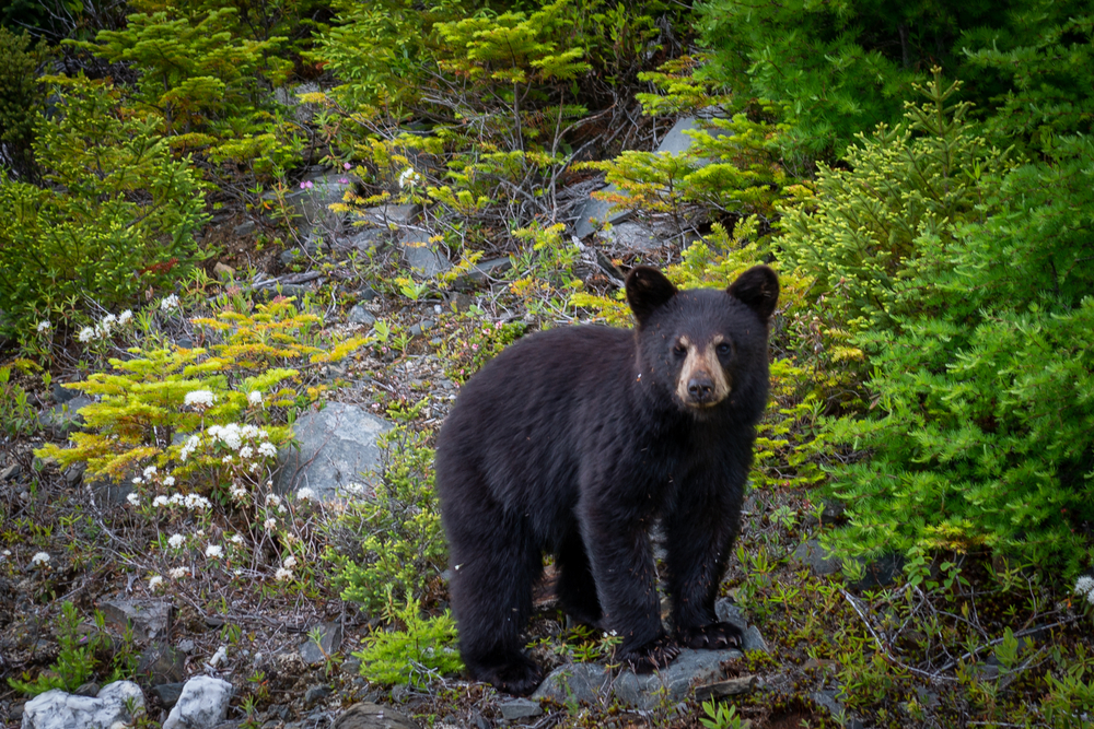
Being Bear Aware

Black bears in the park are wild, and their behavior is sometimes unpredictable. Although extremely rare, attacks on humans have occurred, inflicting serious injuries and death. Treat all bear encounters with extreme caution and follow these guidelines:

Encounters Along the Trail

black bear in smokies

Remain watchful. If you see a bear in the distance, do not approach it. If your presence causes the bear to change its behavior (stops feeding, changes its travel direction, watches you, etc.) – YOU’RE TOO CLOSE.

Being too close may also promote aggressive behavior from the bear, such as running toward you, making loud noises or swatting the ground. The bear is demanding more space. Don’t run, but slowly back away watching the bear. Try to increase the distance between you and the bear. The bear will probably do the same.

If a bear persistently follows or approaches you, typically without vocalizing or paw swatting, try changing your direction. If the bear continues to follow you, stand your ground. If the bear gets closer, begin talking loudly or shouting at it. Act aggressively and try to intimidate the bear.

If you have companions, act together as a group. Make yourselves look as large as possible (for example, move to higher ground). Throw non-food objects such as rocks at the bear. Use a deterrent such as a stout stick if you have one. Don’t run, and don’t turn away from the bear.

Don’t leave food for the bear; this encourages further problems. Most injuries from black bear attacks are minor and result from a bear attempting to get at people’s food. If the bear’s behavior indicates that it is after your food and you’re physically attacked, separate yourself from the food and slowly back away.

If the bear shows no interest in your food and you’re physically attacked, fight back aggressively with any available object — the bear may consider you as prey! Help protect others and report all bear incidents to a park ranger immediately! Above all, keep your distance from bears!

Encounters in Camp

The best way to avoid bears is not to attract them. Keep cooking and sleeping areas separate. Keep tents and sleeping bags free of food odors; do not store food, garbage or other attractants (i.e., toothpaste, soap, etc.) in them.

A clean camp is essential to reducing problems. Pack out all food and litter; don’t bury it or try to burn anything. Proper food storage is required by regulation. Secure all food and other attractants at night or when not in use. Where food storage devices are present, use them. Otherwise, place all odorous items in your pack.

Select two trees 10-20 feet apart with limbs 15 feet high. Using a rock as weight, toss a rope over a limb on the first tree and tie one end to the pack. Repeat this process with the second tree. Raise the pack about 6 feet via the first rope and tie it off. Then, pull the second rope until the pack is up at least 10-feet high and evenly spaced. It must be 4 feet or more from the nearest limb.

Garbage Kills Bears!

  • If a bear approaches you, frighten it by yelling, banging pans together or throwing rocks
  • Pack out ALL your trash, don’t bury or burn anything
  • Do not cook or store food in or near your tent
  • Secure all food, toothpaste, soap and trash at night or when not in use